Cheng Xuan Li
CompleXities:
Towards a Methodological Framework for A Numerical Taxonomy of Cities and Urban Design
Keywords: Urban Spaces, Visual Qualities, Isovist, Cluster Analysis, Gaussian Mixture Model (GMM)
Year: 2024
Part of the M.Arch Thesis at Architectural Association
Awarded Technical Studies High Pass
CompleXities:
Towards a Methodological Framework for A Numerical Taxonomy of Cities and Urban Design
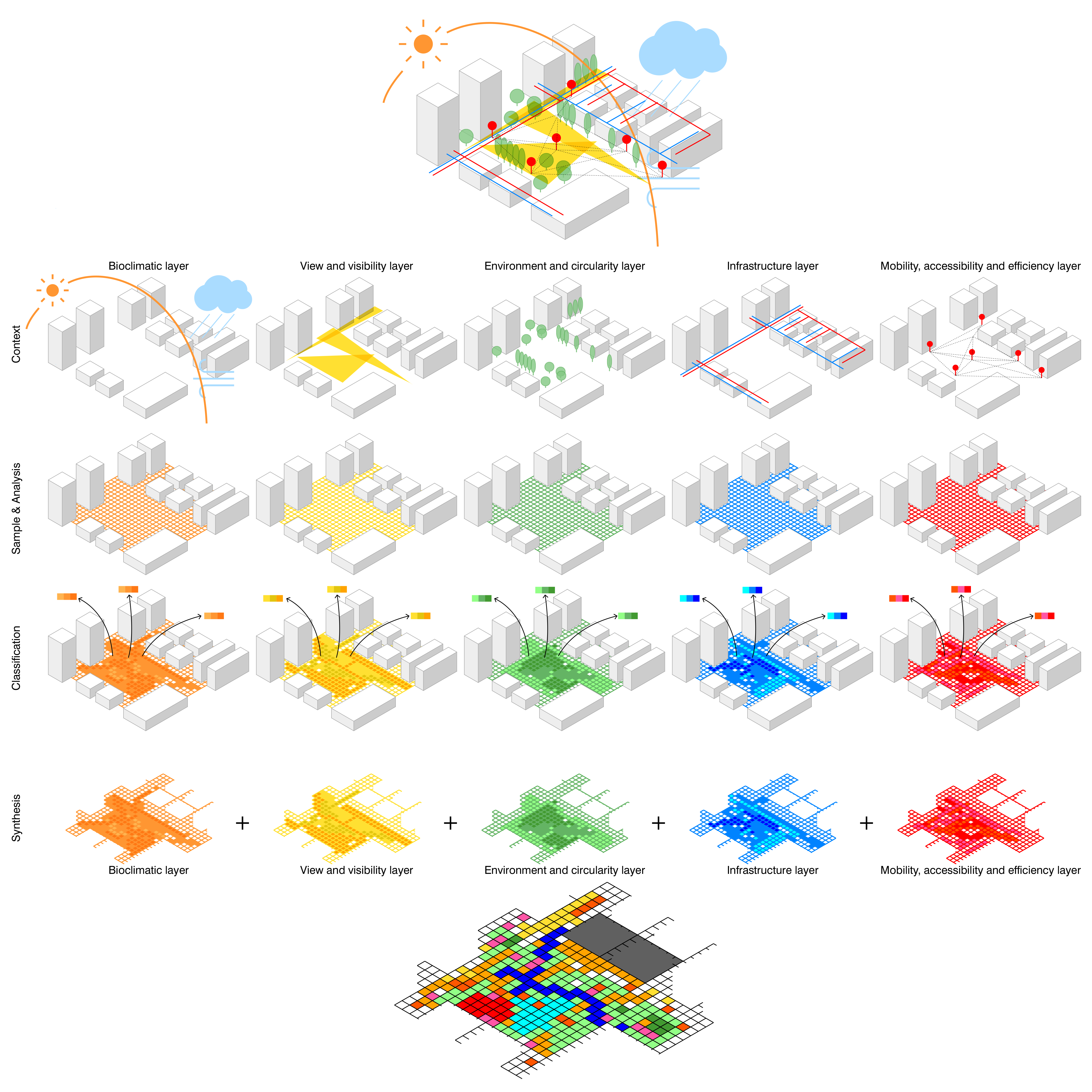
This report introduces an experimental method to classify urban form and assess view and visibility in public spaces. Using the 'Isovist' tool, it maps out visibility attributes across urban conditions, generating an analytical dataset. Advanced analytics like Gaussian Mixture Model reveal 10 urban space types automatically, based on inherent data patterns. This data-driven approach not only offers fast classification but also aids in urban analytics, design, and literal transformation of outcomes into street furniture. Interactive versions provide designers with instant feedback.
Aims and Objectives
Cities are complex systems of agents and relationships. The city in its built reality and super structural construct is a complex synthesis of multiple aspects of human life: history, traditions, religion, myths, experiences, but also architecture, economics, scientific and technological infrastructure, planning, etc. Thus, it has been a challenging endeavour as to capture the complex systems of various qualities of cities. In the discipline of architecture and the built environment, there has been a particular focus on the research on the shape and the relationship of built forms. However, conventionally, the analysis of built forms are often qualitative and requires laborious reproduction of drawings. Recent years, with the evolution of data sciences and urban analytics, consistent quantitative readings of urban form become possible. This report aims to propose an experimental workflow for the quantification of the qualities of urban form not in the 'built figure' but in the 'left void': the public spaces enclosed (or not enclosed) by built forms.
Urban Analytics
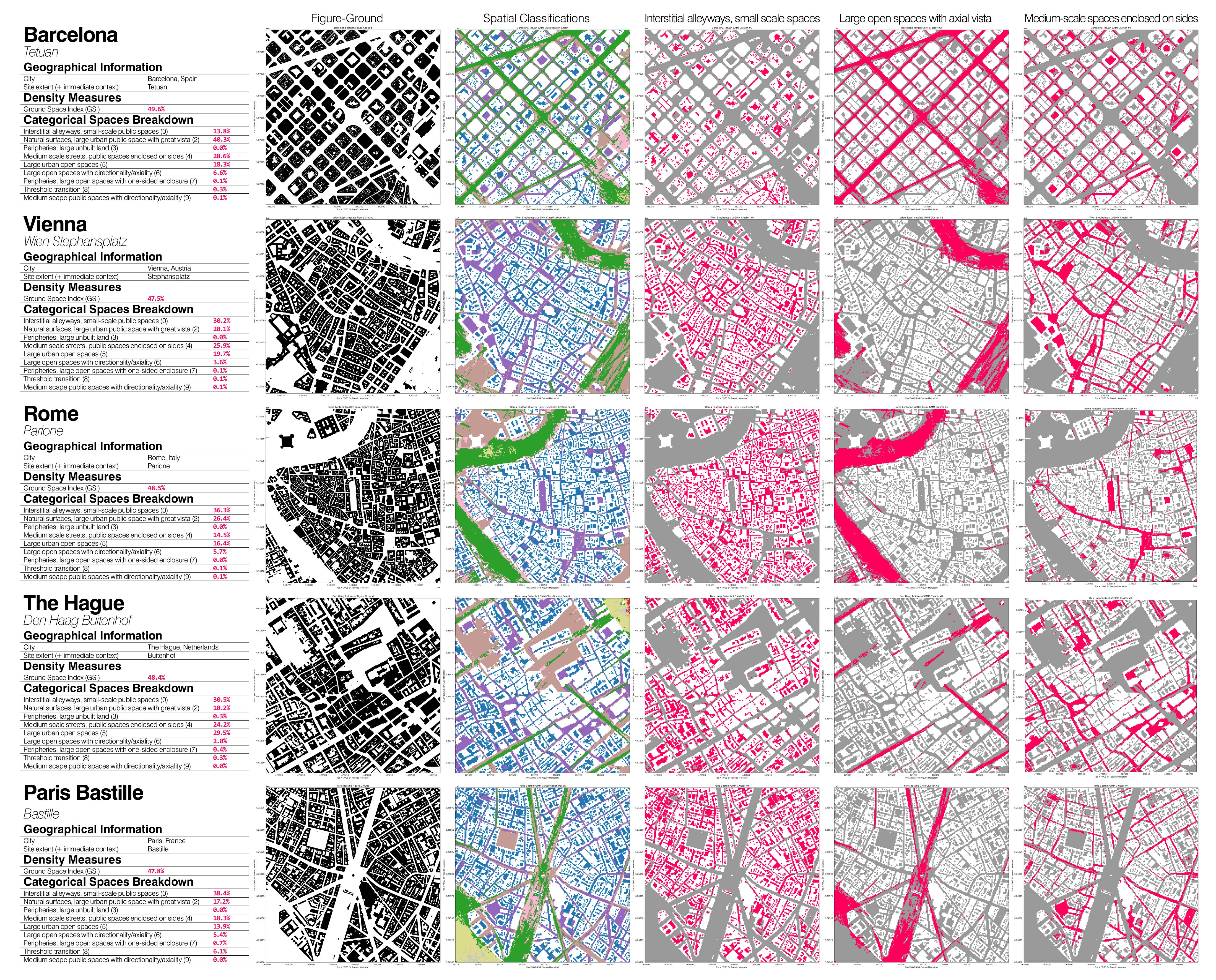
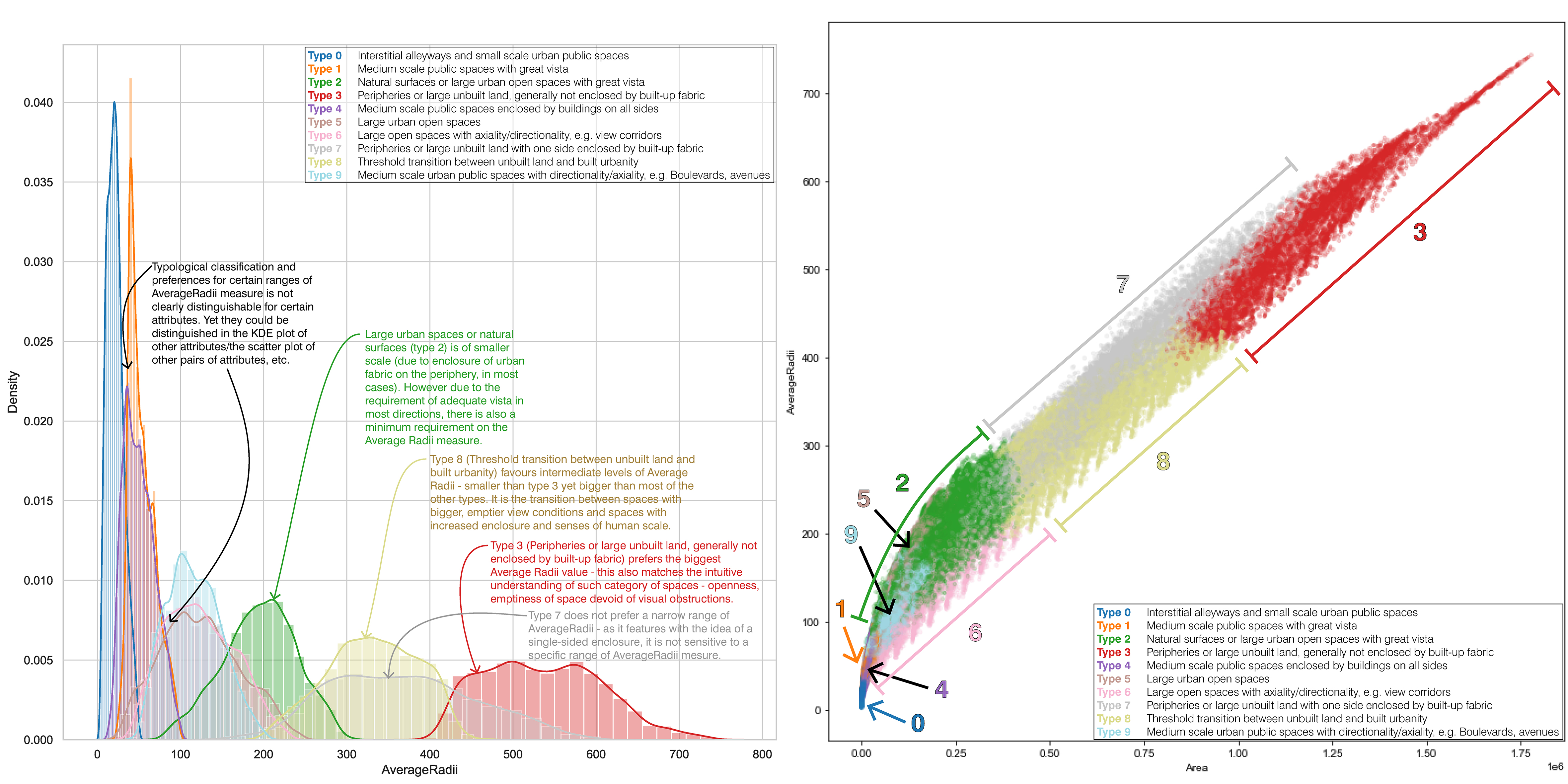
To characterise and to critically reflect the similarities and differences of urban forms and urban spaces across contexts, this report presents an experimental methodology for the classification of urban spaces into types. The particular aspect of analysis which this paper has tested on, and is certainly aiming to transcend, is the assessment of view and visibility in the urban public space. By mapping out the ‘Isovist’ - an analytical tool originally put forward by (Benedikt, 1979), and later adopted by the space syntax group to carry out view analysis in smaller-scale architectural spaces - this methodology seeks to map out ‘isovists’ across the public spaces of an urban condition, and aggregated 10 attributes out of each ‘isovist’ analysed. These 10 attributes are indicative of the angle-specific visibility, vista, etc. of a given location. The aggregation of the 10 attributes of each sample point across various case studies of built and unrealised urban plans, constitutes the ‘analytical dataset’.
Classification
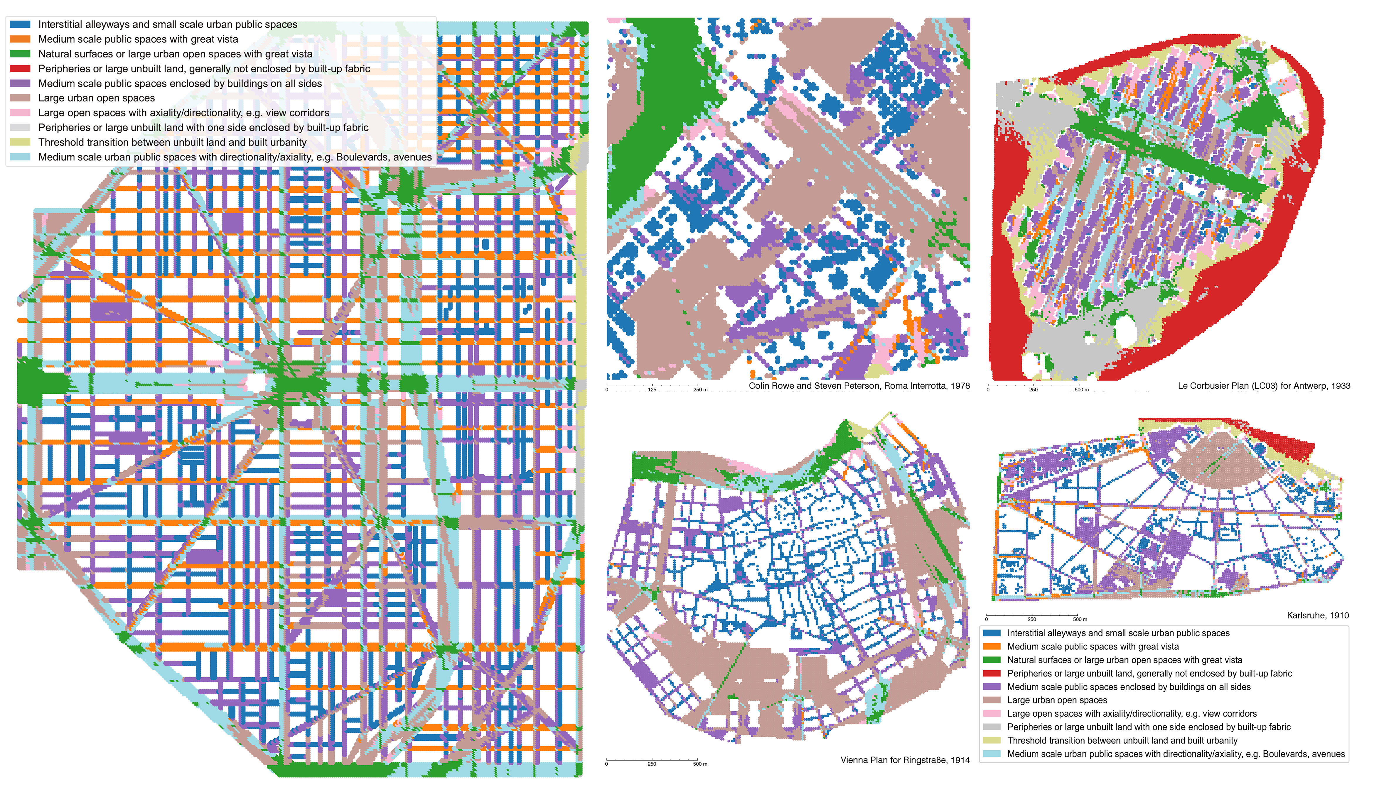
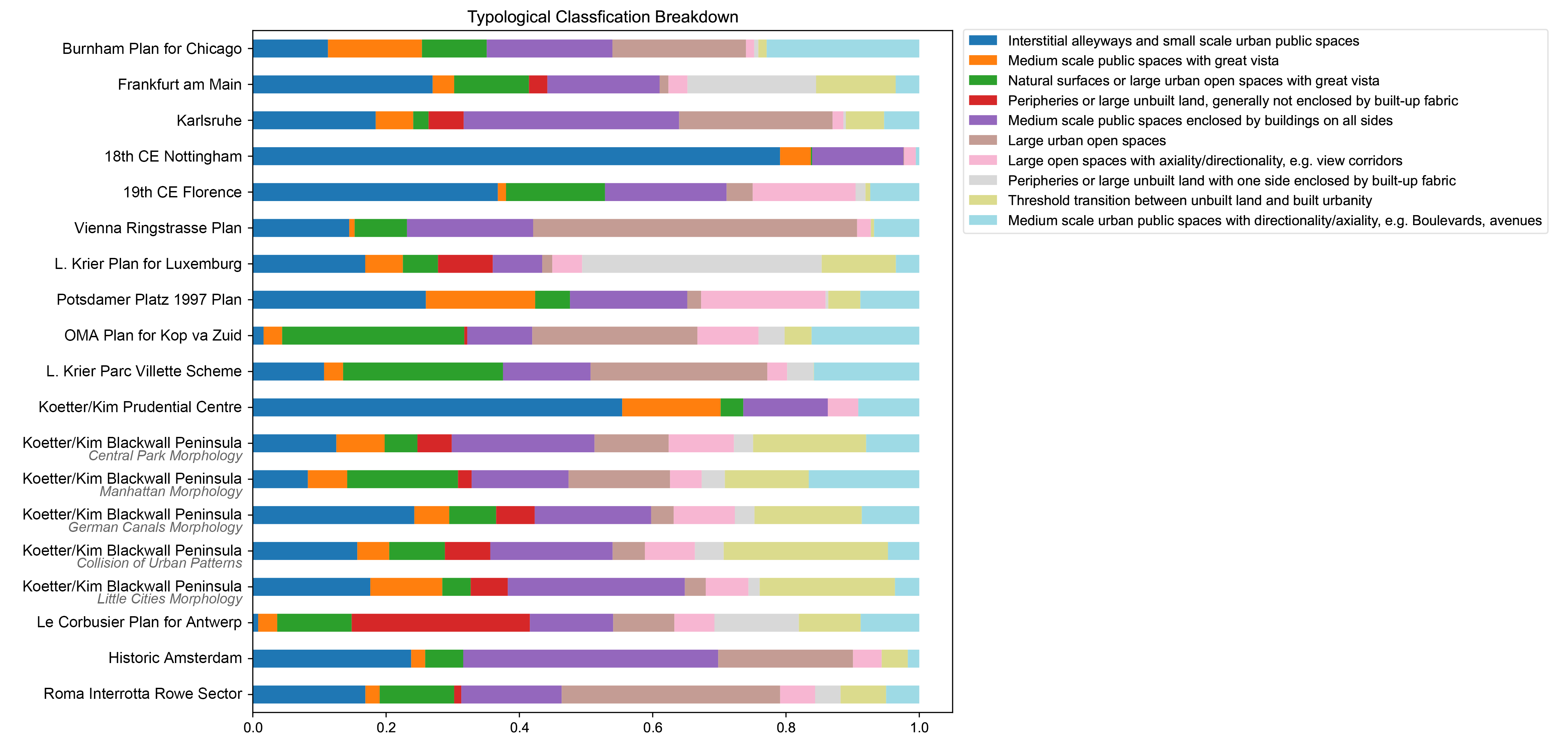
Using advanced data analytics tools such as a Gaussian Mixture Model (GMM), 10 categorical types of urban public spaces are discovered. Contrary to traditional practices of typological research, the determination of each type and the criterion for qualifying for each type is automatically deducted, based on the inherent patterns of data embedded in the ‘analytical dataset’ generated by mapping out ‘isovists’ and their attributes.
Application
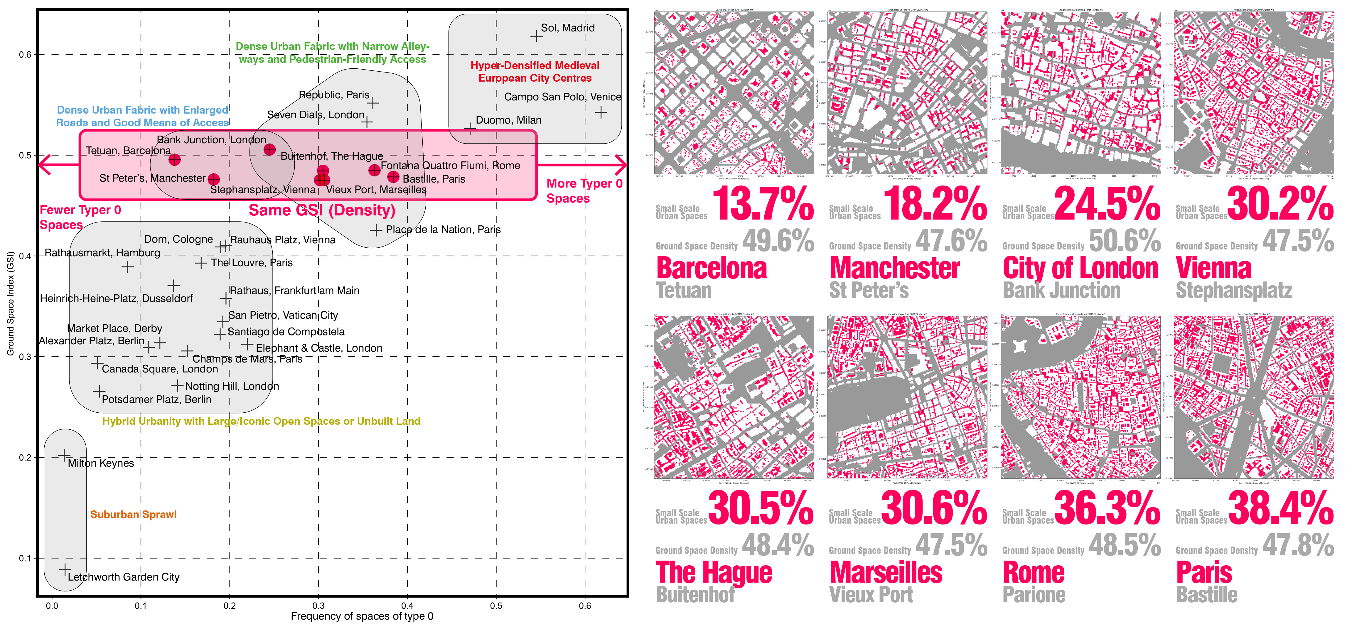
The data-driven categorisation of urban spaces not only produces a reliable, automatic, and fast classification result but also sheds light on many other potentialities. For example, in the discipline of urban analytics, this report presents a workflow to compare the relationship between density and the proportion of interstitial, human-scale alleyways in the urban environment. The result of this analytical tool is also inspiring in the ‘literal’ transformation of the outcome patterns into street furniture and paving since, by definition, the outcome of this analysis is directly indicative of a certain visual quality of the space. In the realm of urban design, an interactive version of this analytical tool is available for instantaneous feedback for designers.